MAPPING THE SITES
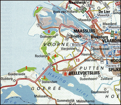
Tom Tom Flickr. Lots of notes and still adding. This is for my friend Karen from Nebraska. It shows many of the locations my pictures were taken and some links to sets of my Flickr Friends. In green are marked the nature reserves. Light blue in the left is the North Sea. Dark blue bottom right is the Haringvliet a freshwater lake with Hellevoetsluis (8) clearly marked on its northern shore. North is the top of the map.
1. De Kwade Hoek
2. Scheelhoek
3. Voornes Duin
4. Annabos (the Anna-forest where the black swans live)
5. Quackjeswater and Quakgors
6. Oostvoornse Meer (a saltwaterlake)
7. Blokkendam (a dike of big concrete blocks in the North Sea, kayakingsite)
8. Hellevoetsluis (the red dot is where we live)
All nature reserves are easily within a 30 minutes drive from homeport Hellevoetsluis.


0 Comments:
Post a Comment
<< Home